Western
Rock Art
Research
Rock Art
Research
Projects
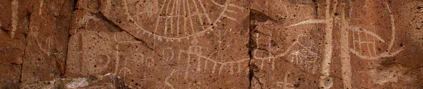
- Finishing the site record for CA-INY-123 in Saline Valley, CA. This site contains over 500 panels of rock art, over 100 rock rings, and over 1,000 rock features.
- Finishing the site record for an extensive rock art site called “Land Hill” on the Santa Clara River outside of St. George, UT for the Bureau of Land Management.
- Participated in the archaeological documentation, analysis, tribal consultation, and final report for prehistoric rock art, historic inscriptions, and rock modifications in Zion National Park, UT.
- Produced scale drawings of a cache of ten large obsidian blades found on private property south of Bishop, CA.
- Documented three petroglyph sites in the White Mountains of California for the Inyo National Forest.
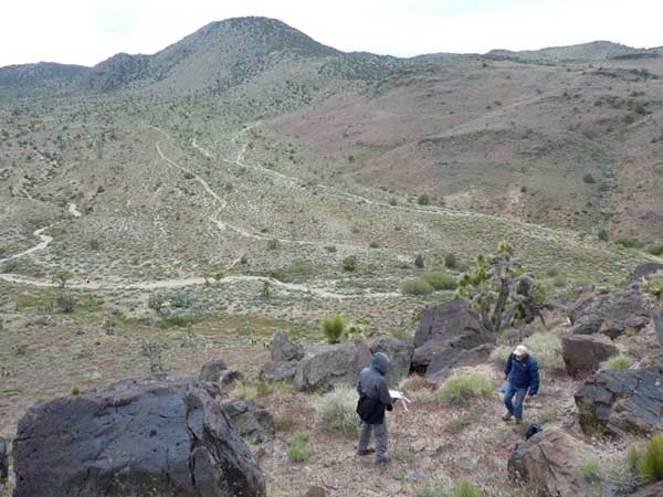
- Assisted in a damage assessment on a vandalized rock art site on the Volcanic Tablelands of California for the Bureau of Land Management.
- Assisted in survey and documentation of a large prehistoric habitation site in the southern Sierra Nevada Mountains of California as part of a mitigation project for the Bureau of Land Management.
- Returned to Australia to finish field-work with the Wardaman People. Documented 24 art sites and assisted newly-formed Wardaman Rangers in cleaning brush, and other debris from the vicinity of sacred rock art sites.
- Assisted in survey and documentation of twenty-eight rock art sites in northwestern Australia as part of the Kimberley Visions Project, a five-year project undertaken by several Australian Universities.
- Produce and publish “Rock Art East of the Range of Light.” First regional overview in 50 years.
- Finish drawings and update of Red Canyon site (300 panels) on Volcanic Tableland for the BLM Bishop Field Office.
- Assist in documentation of extensive habitation/rock art rock-shelters in Inyo Mountains for the Inyo National Forest.
- Perform survey and documentation of earliest known wagon road connecting the Owens Valley with points north (locating an even earlier road in the process). Project Report for CA-170-16-23 Round Fire OHV – Cultural ESR Survey. Prepared for the Bureau of Land Management Bishop Resource Area.
- Assisted the Bureau of Land Management in St. George in cleaning graffiti from rock art located in caves and exposed boulders in Red Cliff Canyon. WRAR also updated the site report.
- Surveyed over 500 acres Red Cliffs National Conservation Area for the Bureau of Land Management, St. George, UT office, resulting in the documentation and final reporting of 23 archaeological sites and 22 archaeological isolates.
- Assisted in survey and documentation of over 300 acres associated with prehistoric water canals in the Owens Valley, CA.
- Returned to Australia to work with the Wardaman People. Documented rock art in 21 rock shelters, and recorded the associated traditional knowledge of Elder Yidumduma Bill Harney for 5 of those sites. Attended and presented information at several management meetings. Assisted in planning the first bio-diversity survey of Wardaman lands.
- In 2014 Western Rock Art Research continued a project in Washington County, UT that began in 2008. Between this time, a total of 67 rock art sites, and 106 other archaeological sites have been recorded for the Bureau of Land Management.
- Through a grant awarded from the National Conservation Foundation, WRAR surveyed nearly 500 acres on National Conservation Lands in the Owens Valley, CA. This work resulted in documentation of 38 archaeological sites, 26 of which contained rock art. Project reports were produced for the Bureau of Land Management, Bishop, CA.
- Conducted meetings with four tribal groups from Owens Valley, CA to discuss the future site management within the Owens Valley.
- Australian researchers Jo McDonald and Peter Veth visited known rock art sites in the Owens Valley, CA with intent to compare arid lands rock art from the two continents.
- Don Christensen, Jerry Dickey and Steve Freers published their book: Rock Art of the Grand Canyon.
- Assisted in performing damage assessments on four vandalism projects in the Owens Valley and Chalfant Valley, CA for the Bureau of Land Management, Bishop, CA. This work resulted in the survey of 111 acres.
- Assisted in survey and site recordation of wildfire-affected areas near Mono Lake, resulting in approximately 200 acres surveyed, and over 10 sites recorded. and recorded 10+ sites. Records prepared for the Bureau of Land Management, Bishop, CA.
- Assisted in survey and site recordation of wildfire-affected areas near Mono Lake, resulting in approximately 200 acres surveyed, and over 10 sites recorded. and recorded 10+ sites. Records prepared for the Bureau of Land Management, Bishop, CA.
- Assisted in survey of over 2600 acres in the Owens Valley, CA with the Bureau of Land Management, Bishop, CA due to a proposed OHV route. This work resulted in the recordation of 29 sites and over 80 isolates.
- Surveyed and documented sites for the Bureau of Land Management in St. George, UT. With the help of volunteers, nearly 1000 acres were surveyed and over 50 archaeological sites were recorded, 10 of which included rock art. One site was documented at over 160 acres.
- Assisted in survey and site recordation of the “John Fire” wildfire-affected areas near Big Pine, CA. Report prepared for the Bureau of Land Management, Bishop, CA.
- Assisted in survey and site recordation in the Alabama Hills survey. Site records prepared for the Bureau of Land Management, Bishop, CA.
- Surveyed and documented archaeological and rock art sites north of Bishop, CA. This resulted in over 1000 acres surveyed, and the recordation of 70 archaeological sites and 30 isolates. Report prepared for the Bureau of Land Management, Bishop, CA.
- Assisted in survey in and around the town of Mammoth Lakes, CA.
- Performed two small surveys in Washington County, UT, resulting in the recordation of numerous rock art sites.
- Assisted in documentation of rock art sites in Idaho.
- Documented archaeological sites in the northern White Mountains of California. These records are the first submitted to the Inyo National Forest in over 10 years.
- Surveyed and documented sites in Saline Valley, CA, as well as in the northern Coso Range for the Bureau of Land Management, Ridgecrest, CA.
- Received a contract from the Bureau of Land Management in California to perform survey and documentation of areas affected by wildfires on Crater Mountain near Big Pine, CA.
- Documented a stock tank on the Dry Lakes Plateau in the Bodie Hills of California, covered in writings from 1950s era Basque sheepherders.
- Several members continued documenting sites in the Owens Valley, CA and in Washington County, UT.
- Other members continued their work around the Grand Canyon, in Joshua Tree, and in the Mojave Preserve.
- WRAR also continued working on the Wardaman Recording Project in northern Australia.
- Technical specialists of WRAR undertook GIS mapping for site recordation, enhancing site management.
- Website development was begun to augment educational outreach.